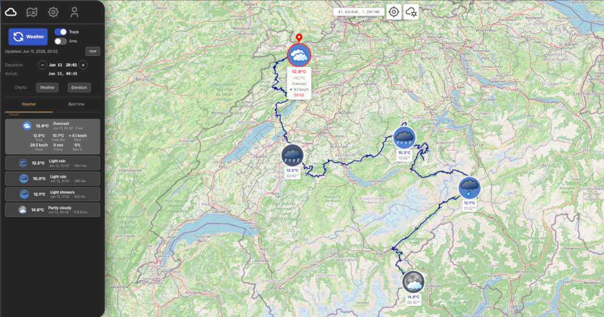
See the weather at every point along your route, timed to your arrival. Navigate the same route live with GPS when the day comes.
From route to forecast to live navigation
Upload a GPX file or paste a Google Maps URL. WeatherGPX reads your track and calculates distances between points.
Tell WeatherGPX when you leave and your realistic average speed. It estimates your arrival time at each point along the route.
Temperature, wind and precipitation at every point, at the exact hour you'll be there. Up to 16 days ahead.
When the day comes, navigate the same route live. Your GPS position tracked on the track, with curve detection, voice guidance and off-track alerts.
Wherever a route meets weather
Rain at the pass? Know what awaits at every ridge, timed to your exact hour. Offline maps for remote routes, live group for sharing the road.
Read more →Summit weather at your exact arrival time. Offline maps when signal disappears in the mountains. Track your group live so nobody gets left behind.
Read more →Headwind or tailwind, rain on the descent, know before you roll out. Offline maps and live group for rides with friends.
Read more →Planning a long drive? Paste your Google Maps route and see the weather at every stop, timed to your arrival. Offline maps and live group for trips with others.
Read more →Timed to the hour you'll be there. Not the forecast for the region.
No route? Enable Area mode for current weather anywhere on the map. Animated radar shows precipitation from the last 45 minutes.
WeatherGPX estimates when you'll reach each point and fetches the forecast for that exact hour. The weather at the pass when you cross it, not at dawn.
Not sure when to leave? WeatherGPX calculates the 5 best departure slots over the next 16 days and ranks them by conditions across your whole route.
Plan up to 16 days ahead. Altitude changes the forecast, WeatherGPX accounts for it. Powered by Open-Meteo, covering any route, any country.
Your position on the route, continuously. Alerts before things go wrong.
Your position tracked on the route. The map follows you, shows what's ahead, how far remains, and your ETA at the end.
A panel shows the angle and distance to the next bend before you reach it. Useful on mountain roads and unfamiliar routes.
Announces upcoming curves, off-track situations and wrong direction. Speaks in your language. Off by default, zero phone interaction while riding.
The navigation HUD shows the next weather point along your route while you ride. Temperature, precipitation and distance, always in view.
Real-time GPS sharing for any outdoor activity, no account needed.
Share your GPS position in real time with others on the same route. Everyone appears as a dot on the map, updated every 3 seconds. No account needed.
One tap sends an SOS alert to the whole group. A red banner with your name appears on all their screens. Anyone can cancel once the situation is resolved.
No account, no credit card , open it and get your first weather forecast in under a minute.
Why is there a paid plan? Weather forecasts and cloud storage have real costs. Subscribing covers them , and directly supports the development of WeatherGPX, which is built and maintained by one person.
WeatherGPX was built by an independent hiker and biker who ran into the same problem too many times: standing in the middle of nowhere, unsure whether to push on or turn back, with no real sense of what the weather was doing further along the route. The classic forecast, a city, a single point, a vague icon, just doesn't cut it when you're off-road and the next pass is two hours away.
WeatherGPX is free to use. Your tracks, weather data and map tiles are stored on your device, even without a connection you can access what you loaded before heading out. With a subscription, everything syncs to the cloud across all your devices.
Free, no account needed, works anywhere in the world.